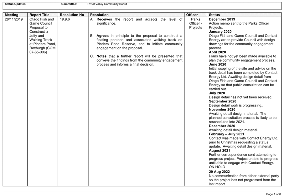
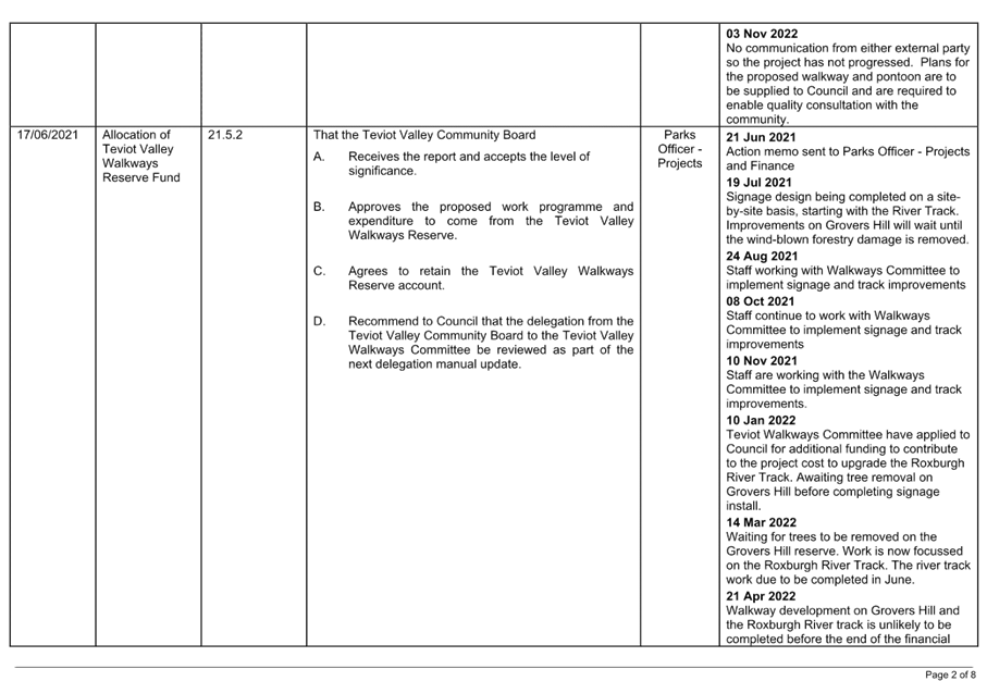
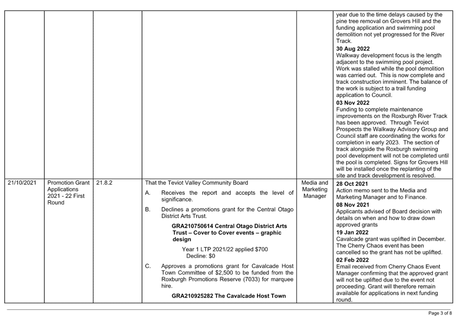
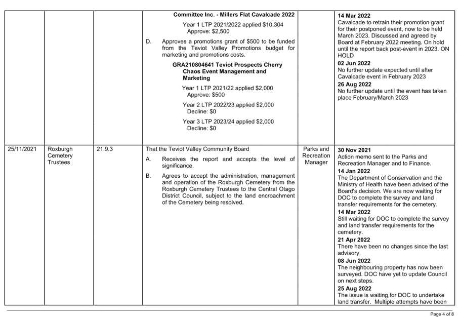
5 Reports
23.1.2 Application
to Stop Part of Branxholm Street
Doc ID: 605823
1. Purpose of Report
To consider an
application to stop an unformed section of Branxholm Street, to legalise an historic
encroachment, in accordance with the provisions of the Public Works Act 1981.
|
Recommendations
That the Teviot Valley Community Board
A. Receives
the report and accepts the level of significance.
B. To recommend to Council to approve the proposal to stop the unformed portion
of Branxholm Street identified as Section 1 in figure 5, being approximately
268 square metres, subject to:
- The
applicants paying for the land identified as Section 1 at valuation of
$35,000 including GST (if any).
- The applicants paying all other
costs associated with the stopping.
- The applicant obtaining the
consent of the owner of Lot 1 DP 7225.
- A covenant being registered over
the area identified in figure 18.
- The land being amalgamated with
record of title OT400/197 (Lot 1 DP 4138).
- The final survey plan being
approved by the Chief Executive Officer.
C. Authorises
the Chief Executive to do all that is necessary to give effect to the
resolution.
|
2. Background
Ownership,
Occupation, and Management of Legal Roads
All legal roads were
originally vested in the Crown pursuant to the Public Works Act 1876.
In 1979, all legal roads
(other than government or state highways) vested in fee simple in the council
of the district in which they were situated, making councils road controlling
authorities.
Each road controlling
authority manages their roading network in accordance with a selection of
legislation such as the Local Government Acts 1974 and 2002, the Land Act 1948,
and the Land Transport Act 1998.
Road controlling
authorities also have the power to make bylaws and policies to assist with the
ongoing management of their roads.
Many unformed legal
roads, or parts thereof, appear to be incorporated into adjoining properties,
however adjoining property owners have no legal right of occupation or
ownership of unformed legal roads, or any part thereof, irrespective of how
many years they have been occupying the land as their own.
While the legislation
governing the use of legal roads does not differentiate between formed and
unformed roads, the Land Act 1948 and the Land Transfer Act 2017 prohibit
claims of adverse possession of a road or any other land that is vested in
trust for public use. This is because the right of the general public to pass
and repass over any legal road is held in perpetuity.
Stopping Legal Roads
To ‘stop’ a
legal road or any part thereof, the legal road status must first be revoked.
This enables the land to be freeholded, then sold if it is determined to be
surplus to the road controlling authority’s operational requirements.
Roads can be stopped
subject to the provisions of the Public Works Act 1981 or the Local Government
Act 1974.
Examples of road being
surplus to requirement include the legal road being much wider than the formed
road or the legal road being located on land that is not physically able to be
formed.
A more common reason for
stopping legal road is to address an encroachment.
Encroachment
A property encroachment occurs when someone or something
traverses the legal property boundary.
A roading encroachment
occurs when public access to a legal road is restricted, or where an area of
legal road has been occupied for private use. For example, a building or a fence
which extends onto the legal road, or a balcony which protrudes over the legal road.
If an encroachment is identified, the current owner of the
property is responsible for the encroachment regardless of when the structure
was erected.
Branxholm Street
Branxholm Street (the
road) starts at Edinburgh Street. It runs southwest, parallel to Scotland
Street, then terminates at the intersection of Till Street.
It is a low volume road
which is somewhat disjointed, and only partially formed. The road has an
overall length of approximately 1,360 metres. Its width varies from around 15
to 22 metres.
An overview of the road
is shown below in figure 1.
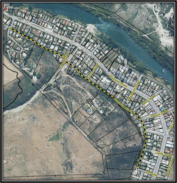
Figure 1 – Overview of Branxholm Street.
The Property
Noel and Sharyn Millar
(the applicants) own the property at 150 Branxholm Street (the Property). The
Property is situated at the southernmost end of Branxholm Street, adjacent to
the western end of Till Street.
The Property is
contained in records of title OT400/197 and OT1C/1032. Record of title
OT400/197 consists of two parcels of land, both parcels are described as Lot 1
Deposited Plan (DP) 4138.
Record of title
OT1C/1032 consists of a single parcel of land which is described as Section 15
Block XXIV Town of Roxburgh (Section 15).
Section 15 was
originally part of a Crown owned water race which ran through and/or behind a
number of properties off the western side of the road. Several titles were
issued for the land under the water race in 1964 with the Crown then disposing
of the titles to the adjacent property owners.
Section 15 dissects Lot
1 DP 4138 which is why Lot 1 is contained in two parcels. The Property has a
total area of 1,043 square metres more or less.
An overview of the
Property is shown below in figure 2.
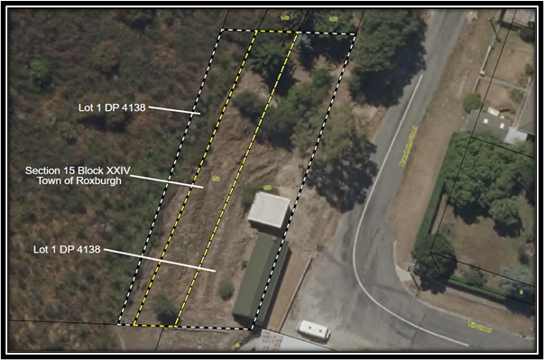
Figure 2 – Overview of the Property situated at
150 Branxholm Street.
The applicants purchased
the Property in June 1990. There is no evidence of a LIM being obtained in
conjunction with that purchase.
Improvements on the Property
include an historic stone cottage (the cottage), and a sleepout with ablutions
and a small deck. Records indicate that the cottage was constructed in the
1870’s. The applicants moved the sleepout onto the Property in 2009 after
obtaining building and land use (resource) consents.
The building consent
provided for the relocation of the sleepout, and the ground works associated
with its placement. Land use consent was also required as the applicants
proposed to breach yard requirements by placing the sleepout closer to the
Branxholm Street boundary than is permitted under District Plan rules.
Applications to breach
yard requirements must give consideration to the adverse effects the proposed
breach may have on the amenity value of the surrounding environment. The
surrounding environment includes neighbouring properties, water bodies, the
character of the streetscape, the roading network, infrastructure, and heritage
values.
An application for
resource consent may be considered non notified if the effects are not more
than minor and affected parties have provided written approval. Where written
approvals are provided effects on those parties cannot be considered in the
consent process. In a roading context, affected parties are likely to be adjoining
landowners.
As the applicants
proposed to breach the road frontage, the Central Otago District Council
(Council), as road controlling authority, was identified as an affected party.
On consideration, the
breach was deemed to have no adverse effect on the roading network and affected
party approval was given. It was also determined that adverse effects on the
wider surrounding environment would be no more than minor, with land use
consent being granted in March 2009.
Boundary Issues and
Geographic Information Systems
Notes attached to the
building consent file indicate that the applicants first contacted Council
regarding their plans to relocate the sleepout to the Property in early 2008.
The file also indicates that there were concerns regarding the identification
of the true legal property boundary.
In that same year (2008)
the applicants engaged a surveyor to identify their true legal boundaries.
While carrying out that
work, the surveyor recorded the northern and southern boundaries as being
‘out’ slightly and the eastern and western boundaries as being
‘out’ quite significantly in comparison to the cadastral boundaries
and aerial photography overlay on the Geographic Information System records.
Geographic Information
Systems (GIS) are computer-based
tools which are used to capture, store, visualise, and analyse digitised
spatial records. The
base layer of GIS is the parcel layer being a digitised version of property
boundaries which have been defined by cadastral survey, then approved by Toitū
Te Whenua Land Information New Zealand (LINZ), as the owner of New
Zealand’s cadastral data.
Some versions of GIS, such as those used by local authorities,
are complex as they contain numerous additional layers. An example of the base
parcel data being attributed to LINZ is shown on the bottom of all maps that
are printed from Council’s GIS as shown below in figure 3.
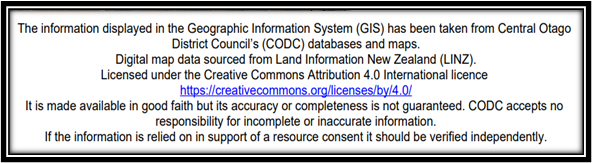
Figure 3 – GIS Disclaimer
In 2015, the
applicant’s surveyor submitted the new digitised survey data to LINZ, and they were asked to correct the base parcel
layer.
Corrections to base
parcel layer are called rubber-sheeting. Rubber-sheeting is the process of
identifying the true legal boundary geospatially by overlaying and comparing
the newly digitised survey data to the existing spatial record. If the existing
spatial record is found to be ‘out’, LINZ will adjust it to reflect
the true legal boundaries.
Rubber-sheeting has become
increasingly common since the introduction of digital survey plans in 2007. It
also means that the accuracy of LINZ’s geospatial records have improved
considerably during the last 15 years.
In areas like Roxburgh,
which have experienced little or no redevelopment during recent times, the
digitised spatial records are known to be very unreliable.
LINZ
confirmed the surveyor’s findings, then corrected their geospatial
records accordingly.
A plan of the Property,
as it was shown in GIS prior to the 2015 correction, is shown below in figure
4.

Figure 4 – Extract of the Base Parcel Layer Prior
to Correction in 2015.
Post
correction, the digitised version of the base parcel layer was noted as being
consistent with the title plan. The correction also showed that the cottage
encroached over the Branxholm Street boundary as shown previously in figure 2.
Application to Stop
Since having their true legal boundaries identified by a
surveyor in 2008, the applicants have contacted Council to discuss remedying the
encroachment of the cottage.
The applicants were advised that a simple road stopping,
undertaken at their cost, would enable them to rectify the encroachment. The
applicants advised they do not consider they are responsible for the encroachment.
In July 2022, the
applicant’s lawyer lodged an application to stop an unformed section of
Branxholm Street. A plan of the proposed stopping, which identified the road to
be stopped as Section 1, is shown below in figure 5.
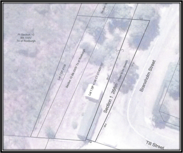
Figure 5 – Plan of Section 1 (Road to Stopped).
The purpose of the
stopping was noted as being to resolve an historic encroachment that had
stemmed from “a
careless Crown surveying exercise” in the 1930s which resulted in the
culturally significant cottage technically encroaching onto Council's unformed
legal road.
The application also
noted that the applicants had unwittingly inherited mistakes of the past and
that they have maintained the berm at their own expense, even though the berm
is located on Council's legal road.
As the applicants
believe the encroachment is not their responsibility, they also believe the
proposed stopping should be undertaken at Council’s cost with the land
identified as Section 1 then being transferred to them for $1.00.
In consideration of the
applicant’s position and to understand the costs, it was agreed that
Section 1 would be valued (at the applicant’s cost) prior to the
presentation of this report.
3. Discussion
Imperial Survey Plans
Prior to the
introduction of the metric system in the 1970’s, surveyors recorded the
survey, occupation, and title data on a single plan. They were also required,
by law, to record the details of any encroachment. These plans are known as imperial survey plans.
DP 4138 is an imperial
survey plan which dates back to August 1930. A full copy of DP 4138 is shown
below in figure 9.
The survey plan is
extensively detailed drawing to the centre right of the plan. The survey plan
shows the details of both the subject land and surrounding properties, the
water race and roads, along with the observation data and occupation details as
they were at the time.
The Roxburgh Borough
Council approved the survey plan in December 1930.
The title plan is the
simpler drawing next to the left hand margin. The Deputy Chief Surveyor
approved the title plan in June 1937.
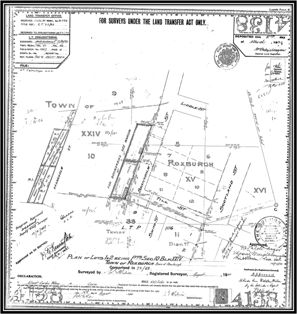
Figure 9 – Full Copy of DP 4138
Surveying (cadastral) is
the discipline of land surveying that relates to the laws of land ownership and
the definition of property boundaries. Approving a survey or title plan relates
purely to the proposed subdivision of the land.
The survey plan for DP 4138 identifies a number of
occupations including fences, stone walls, and a building on an adjacent
property. It also records two encroachments to road. The encroachment and other
occupation notes are highlighted in the magnified extract of the survey plan
which is shown below in figure 10. The applicant’s cottage is shaded
pink.
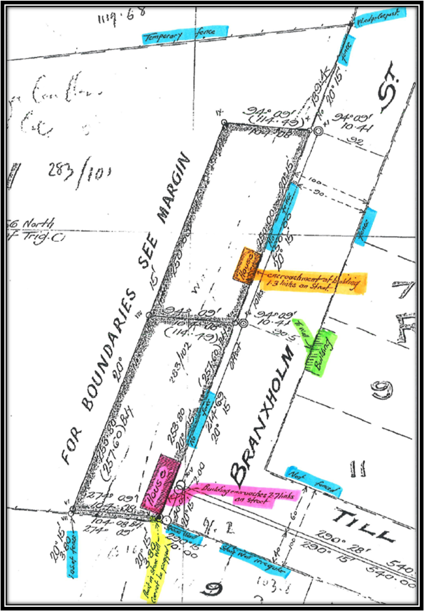
Figure 10 –
Magnified extract of the Survey Plan
As noted previously, the
applicants believe the encroachment resulted a Crown surveying exercise which
was undertaken in the 1930s. While the Crown was the original surveyor of the
land, they had no interest in second survey as they had long since disposed of
the land.
The evidence suggests
that the two encroachments resulted from a simple mistake in identifying the south
eastern boundary. This seems to be reflected on the survey plan which notes
that the south eastern boundary point ‘cannot be pegged’ as the
point is in a ‘stone wall’.
While it is an offence
to move or remove a survey peg, they are often buried or lost over time. If the
stone wall was constructed over the original survey peg, it is conceivable that
the point marked with the red ‘x’ in figure 11, may have been taken
to be the legal boundary marker.
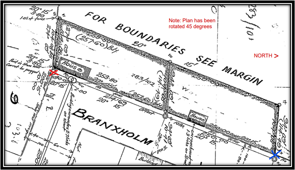
Figure 11 – Possible explanation for boundary
issue.
For example, if a
straight line is drawn from the point marked with the red ‘x’ in
figure 11, to the north eastern boundary point which is represented by the blue
‘x’, the incorrect boundary could have been assumed. If that was
the case, the encroachment would not have been identified until the second
survey was undertaken in the 1930s.
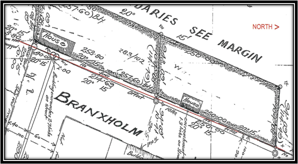
Figure 12 – Possible misrepresentation of the
boundary points.
Roading Network
As noted previously,
Branxholm Street is a low volume road which is somewhat disjointed, and only
partially formed with the legal road width varying from around 15 to 22 metres.
The section of road
which the applicants propose to stop varies from approximately 3.6 metres wide
to 6.8 metres wide. This would leave a clearance of around 2 metres between the
proposed new boundary and the formed carriageway.
Overall, a legal road
width of approximately 15 to 17 metres would be retained as shown below in
figure 13, which is sufficient for roading purposes.
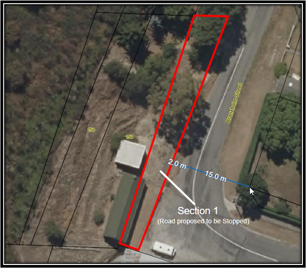
Figure 13 – Legal Roading Corridor and Formed Carriageway.
Legislation and
Policy
The Central Otago
District Council’s Roading Policy determines the appropriate statutory
procedure for stopping a legal road or any part thereof that is under their
control.
The policy for selecting
the correct statutory process is outlined in section 8.5 of Council’s
Roading Policy. The options are as follow:
The Local Government Act
1974 road stopping procedure shall be adopted if one or more of the following
circumstances shall apply:
a) Where
the full width of road is proposed to be stopped and public access will be
removed as a result of the road being stopped; or
b) The
road stopping could injuriously affect or have a negative or adverse impact on
any other property; or
c) The
road stopping has, in the judgment of the Council, the potential to be controversial;
or
d) If
there is any doubt or uncertainty as to which procedure should be used to stop
the road.
The Local Government Act
process requires public notification of the proposal. This involves erecting signs at each end of the road to be stopped,
sending letters to adjoining owners/occupiers and at least two public notices a
week apart in the local newspaper. Members of the public have 40 days in
which to object.
The Public Works Act 1981
road stopping procedure may be adopted when the following
circumstances apply:
e) Where
the proposal is that a part of the road width be stopped and a width of road
which provides public access will remain.
f) Where
no other person, including the public generally, are considered by the Council
in its judgment to be adversely affected by the proposed road stopping;
g) Where other reasonable
access will be provided to replace the access previously provided by the
stopped road (i.e. by the construction of a new road).
It is proposed that
Public Works Act 1981 (the Public Works Act) procedure be adopted for this
application for the following reasons:
· The proposal is to
stop part of the road width only.
· Public access will
not be adversely affected.
The Public Works Act further provides for legal road to be
stopped, sold, and amalgamated with an adjacent title. In this instance,
Section 1 (the stopped road) would be amalgamated with Lot 1 DP 4138, with a
new record of title being issued for the three parcels of land.
Public Notification and Consultation Requirements
As outlined in Section
116 of the Public Works Act, road stoppings are not subject to public
consultation if:
· the road is under
the control of the territorial authority,
· the territorial
authority agrees to the proposed stopping, and:
· adequate road
access to land adjoining the road is left or provided; or
· the owners of the
land adjoining the road or part of the road consent in writing to the stopping.
If the stopping is
approved, the applicants will require the written approval of the owner of Lot
1 DP 7225 as her road frontage would be reduced by about 3.6 metres.
About 20 metres of the
northern boundary of Lot 1 DP 7225 fronts the intersection of Branxholm and Till
Streets. Another 14 metres of that boundary is mutual as shown below in figure
14.
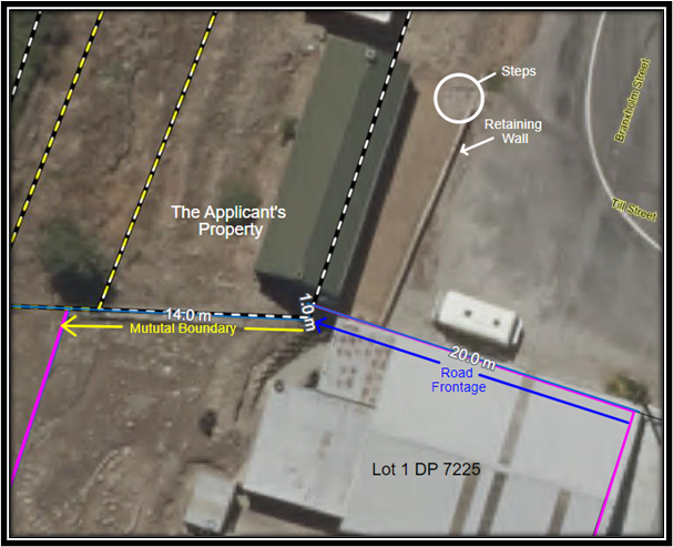
Figure 14 – Northern Boundaries of Lot 1 DP 7225.
A low retaining wall and
stone steps have been constructed on the road immediately adjacent to the edge
of the formed carriageway. The retaining wall reinforces the grassed area in
front of the cottage with the stone steps providing pedestrian access to the
Property.
The retaining wall abuts
the building on Lot 1 DP 7225 as shown below in figure 15.
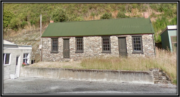 Figure 15 – View of Retaining Wall and Stone
Steps from the Formed Carriageway.
Figure 15 – View of Retaining Wall and Stone
Steps from the Formed Carriageway.
The owner of Lot 1 DP
7225 approached Council enquiring about the road stopping process. After the
process was explained to her, she indicated concern about access the rear of
her property and that visibility from the small window fronting the legal road
(to be stopped) could be impaired by a building or plantings.
Figure 16 – Till Street frontage of Lot 1 DP
7225.
Because of the mutual
boundary and the location of the cottage and retaining wall the road stopping
may impact on that property.
A covenant could for
example, prohibit the construction of any improvements or plantings, could
limit their height, and could also prescribe acceptable styles of fencing on
the mutual boundary. It is recommended that a covenant be registered over the
land immediately in front of the small window that sits just above the height
of the retaining wall.
An example of the area
which could be subject to the covenant is shown below in figure 18.
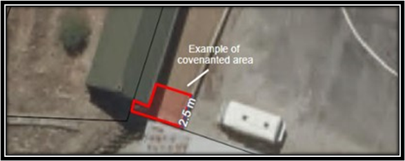
Figure 18 – Example of covenanted area.
Utility Networks
Many legal roads,
whether formed or not, contain electrical, telecommunication, or water
infrastructure. If there are any services in a road that is to be stopped,
these can be protected by registering an easement on the resulting title.
Network operators have
confirmed that there is no utility infrastructure in the section of the road
which the applicants propose to stop.
Financial
Council’s Roading
Policy determines that the applicant is responsible for all costs associated
with the road stopping. This includes purchase of the land at market valuation.
Section 1 (the land/road to be stopped) has been valued at $35,000 including
GST (if any). This equates to about $131 including GST (if any) per square
metre.
The applicants have
requested that the land be transferred to them for $1.00 as they consider the
encroachment to be Council’s fault, however. The identification of
property boundaries on the ground (now or historically) is the responsibility
of the property owner.
Transferring the land
for less than the market valuation would also be contrary to Council’s
Roading Policy.
If the applicants do not
wish to pay market valuation for Section 1, the encroachment could be legalised
by stopping a much smaller section of the road.
For example, the section
of road shaded red in figure 19 below, has an approximate area of just 46 square
metres. If the applicant’s preferred, this smaller section of the road
would be worth approximately $6,025 including GST (if any). This option may
also be preferable to the owner of Lot 1 DP 7225.
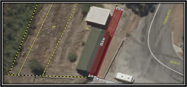
Figure 19 – Plan of less expensive option for
legalising the encroachment.
4. Options
Option 1 –
(Recommended)
To recommend to Council
to approve the proposal to stop the unformed portion of Branxholm Street
identified as Section 1 in figure 5, being approximately 268 square metres,
subject to:
- The
applicants paying for the land identified as Section 1 at valuation of $35,000
including GST (if any).
- The
applicants paying all other costs associated with the stopping.
- The
applicant obtaining the consent of the owner of Lot 1 DP 7225.
- A
covenant being registered over the area identified in figure 18.
- The
land being amalgamated with record of title OT400/197 (Lot 1 DP 4138).
- The
final survey plan being approved by the Chief Executive Officer.
Advantages:
· The
applicant’s occupation (encroachment) of the legal road will be
legalised.
· Will
not compromise the roading network.
· The
income received will be used to address other public roading issues.
· Recognises
the provisions of Council’s Roading Policy.
· Is
consistent with the Public Works Act 1981.
Disadvantages:
· The
applicants may not have anticipated having to purchase the land at valuation.
Option 2
To recommend to Council
to approve the proposal to stop the smaller unformed portion of Branxholm
Street as shown in figure 19, being approximately 46 square metres, subject to:
- The
applicants paying for the land identified at valuation of $6,025 including GST
(if any).
- The
applicants paying all other costs associated with the stopping.
- The
applicant obtaining the consent of the owner of Lot 1 DP 7225.
- The
land being amalgamated with record of title OT400/197 (Lot 1 DP 4138).
- The
final survey plan being approved by the Chief Executive Officer.
Advantages:
· The
applicant’s occupation (encroachment) of the legal road will be
legalised.
· Will
not compromise the roading network.
· May
be more palatable to the owner of Lot 1 DP 7225.
· The
income received will be used to address other public roading issues.
· Recognises
the provisions of Council’s Roading Policy.
· Is
consistent with the Public Works Act 1981.
Disadvantages:
· The
applicants may not have anticipated having to purchase the land at valuation.
· Stopping
a smaller section of the road may not suit the applicant’s requirements.
Option
3
To not recommend to
Council to approve the proposal to stop an unformed section of Branxholm
Street.
Advantages:
· None,
as the proposed stopping will not compromise the roading network.
Disadvantages:
· The
applicant’s occupation (encroachment) of the legal road will not be
legalised.
· Would
resolve the concerns of the owner of Lot 1 DP 7225.
· Additional
income will not be available to address other road encroachment or access
issues.
· Does
not recognise the provisions of Council’s Roading Policy.
· Does
not recognise that the proposal is consistent with the Public Works Act 1981.
5. Compliance
|
Local Government Act 2002 Purpose Provisions
|
This decision promotes the economic wellbeing of the
community by generating income from the disposal of land that is held (but
not required) for roading purposes.
|
|
Financial implications – Is this decision consistent with
proposed activities and budgets in long term plan/annual plan?
|
There are no negative
financial implications associated with the recommended option. The applicants
are required to pay market value for the land, as well as all other
associated costs.
Funds received from the
disposal will then be available to address other public encroachment or
access issues.
|
|
Decision consistent with other Council plans and policies? Such as
the District Plan, Economic Development Strategy etc.
|
Council’s Road Stopping Policy applies to this
application.
Consideration of this policy has ensured that the
appropriate statutory process, being to stop the road in accordance with the
provisions of the Public Works Act 1981.
|
|
Considerations as to sustainability, the environment and climate
change impacts
|
No sustainability, environmental or climate change
impacts are related to the decision to stop this short unnamed unformed road.
|
|
Risks Analysis
|
No risks to Council are
associated with the recommended option.
|
|
Significance, Consultation and Engagement (internal and external)
|
The Significance and
Engagement Policy has been considered, with none of the criteria being met or
exceeded.
Notice of the completed road stopping will be published
in the New Zealand Gazette.
|
6. Next
Steps
1. Community Board approval February
2023
2. Council approval February
2023
3. Survey and LINZ Accredited Supplier engaged March
2023
4. Survey Plan approved Mid
2023
5. Gazette notice published Mid
2023
7. Attachments
Nil
|
Report
author:
|
Reviewed
and authorised by:
|
|

|

|
|
Linda
Stronach
|
Louise
van der Voort
|
|
Team
Leader - Statutory Property
|
Group
Manager – Planning and Infrastructure
|
|
13/01/2023
|
26/01/2023
|